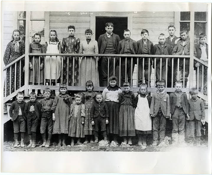
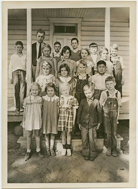
Students and a teacher from the Harrison School on Harrison Road, between Banks and Mountaindale in Washington County, Oregon. This photograph was taken circa 1892. The students stand on and in front of the school's porch. A Hillsboro Argus article published decades later provided the names of the students and teacher: (Front row, from left) Otis Purdin, Fred Schlegel, Eugene Northrup, Ivy McMurry, Mabel Northrup, Ella Schlegel, Edwin Schlegel, Lurah Cornelius, Eva Cornelius, Louise Rieben, Ellis Purdin, Will Rieben; (top row) Mary Rieben, Rose Schlegel, Elizabeth Rieben, Minnie Northrup, Pearl McMurry, Frank Armentrout, Arthur Schelgel, Charles Purdin, Wesley Schlegel, George Cronkite (teacher), Fred McMurry and Nelse Cornelius.
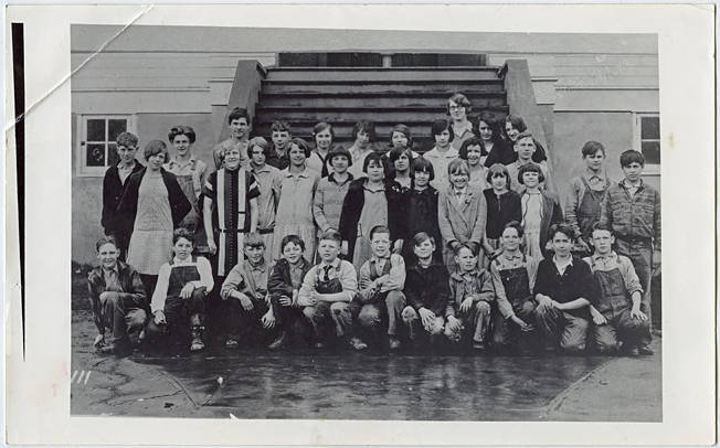
Students gathered at the base of a stairway leading to the front entrance of a building, probably a school. This photograph was likely taken between 1924-1933, based on the hair and clothing styles present. The students probably belonged to a school in Washington County, Oregon.
Black and white image of students arranged on the front steps of their school, with their teacher, Mrs. R. A. Withycomb, standing in the background. Johnson School served students in and around the Blooming community, which was an unincorporated area south of Cornelius originally known for its large concentration of German settlers.
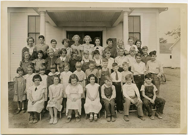
Black and white image of students standing in front of their school. With two rooms, Kinton was one of the larger schools in the county, and one of the first to have offered high school grades outside of the larger communities such as Hillsboro. By the time of this photo, high school students were being bused into Hillsboro for classes. The teacher at the time of this photo was identified as Miss Helen Schneider, most likely the woman standing to the left at the back of the group. See WCMpic_013090 for another image of this school. Though museum records identify these images as being taken on the same day, October 5, 1936, they most likely represent two different school years. The old school building, long abandoned, can still be seen in Kinton.
Black and white image of ten students standing outside of their school. Founded in 1856, Jacktown school was located south of Hillsboro. In 1910, the district built a new one-room school at the intersection of Farmington and Jacktown Roads. During the war years of the 1940s, it became increasingly difficult to maintain and staff these small, one-room schools, and many districts consolidated with each other. Jacktown's 1910 school building was razed after 1949, when the district merged with several others to form what is now Groner Consolidated Elementary. This image was taken in the mid-1930s, and the teacher is identified in museum records as Miss Evelyn Hesse. She is possibly the woman standing in the back row at the left end. See WCMpic_013086 and WCMpic_013088 for other images of Jacktown School. Though museum records show these three images as all taken on the same date, 1936-10-05, it is more likely they represent three different school years, and the two smaller groups could represent a single class or grade level.
Black and white image of ten students standing outside of their school. Founded in 1856, Jacktown school was located south of Hillsboro. In 1910, the district built a new one-room school at the intersection of Farmington and Jacktown Roads. During the war years of the 1940s, it became increasingly difficult to maintain and staff these small, one-room schools, and many districts consolidated with each other. Jacktown's last school was razed after 1949, when the district merged with several others to form what is now Groner Consolidated Elementary. This image was taken in the mid-1930s, and the teacher is identified in museum records as Miss Evelyn Hesse. She is possibly the woman standing in the back row, second from the right. See WCMpic_013087 and WCMpic_013088 for other images of Jacktown School. Though museum records show these three images as all taken on the same date, 1936-10-05, it is more likely they represent three different school years, and the two smaller groups could represent a single class or grade level.
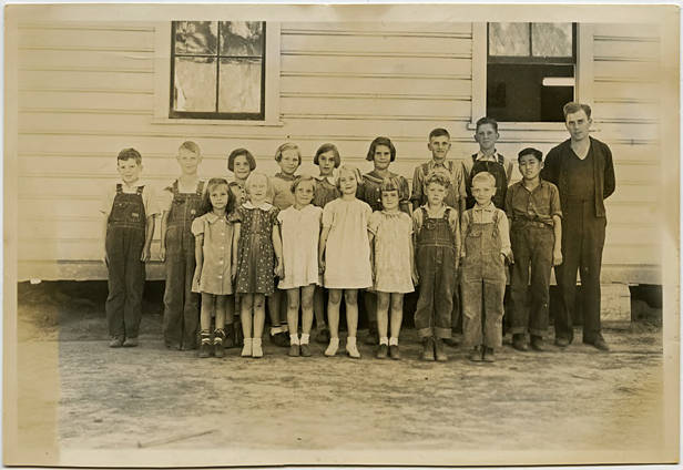
Black and white image of a group of children standing beside their school. Their teacher stands at the right of the image, and is identified in museum records as Mr. J. Jons. Iowa Hill rises to the east of Gaston and was named because most of the original settlers came from Iowa. See WCMpic_013084 for another image of this school, most likely taken the year before this image.
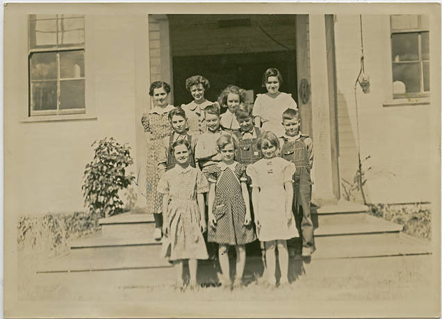
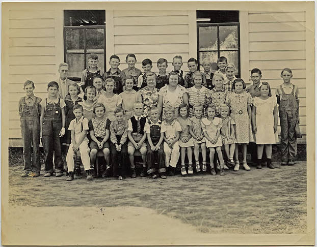
Black and white image of a group of children assembled outside a schoolhouse. Their teacher for this year, identified in museum records as Mrs. Jaenicke, stands at the left side of the back row. Since there were 42 students registered this year, it is likely these students all belonged to one 'class' or grade level. Blooming was a small community just south of Cornelius and was once known as 'the German Settlement.'
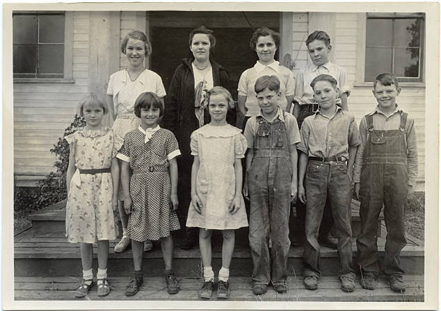
Black and white image of a group of children assembled outside a schoolhouse. Their teacher, identified in museum records as Edwin Heefer, stands at the left side of the back row. Blooming was a small community just south of Cornelius, and the school was one of the smaller 'walking' schools in the county, with only 35 students.
Black and white image of students seated and standing in front of their school. With two rooms, Kinton was one of the larger schools in the county, and one of the first to have offered high school grades outside of the larger communities such as Hillsboro. By the time of this photo, high school students were being bused into Hillsboro for classes. The teacher at the time of this photo was identified as Miss Helen Schneider, most likely the woman standing to the left at the back of the group. See WCMpic_013088 for another image of this school. Though museum records identify these images as being taken on the same day, October 5, 1936, they most likely represent two different school years. The old school building, long abandoned, can still be seen in Kinton.
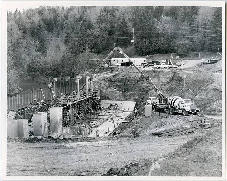
Black and white image of concrete being poured into forms at what will be Scoggins Dam. Scoggins creek can be seen in the background. Scoggins Dam was built in the 1970s and is a zoned, earth-fill dam.
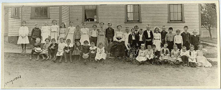
Black and white image of a group of younger students standing and seated in two rows along a boardwalk beside a building. A woman, possibly their teacher, sits in a chair in the middle of the two rows. She wears a light colored shirt with bishop sleeves, and a dark skirt with cut out detailing near the hem. The building behind them is typical of schools and churches of the era, but is not identified. Some of the younger boys wear ruffled collars and short pants, while most of the girls wear dresses with long sleeves and ruffles. Lettering in the bottom of the image indicates it was taken in May, 1903.
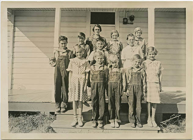
Black and white image of a group of children standing on the steps and front porch of their school. Their teacher is identified in museum records as Mr. J. Jons. Iowa Hill rises to the east of Gaston and was named because most of the original settlers came from Iowa.
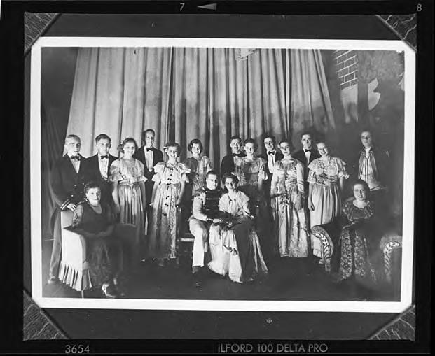
Black and white image of a group of students in costume, gathered on a stage set. Most of the women appear to wear evening dresses, while the young men are mostly in suits with bow ties. One young man wears some kind of uniform.
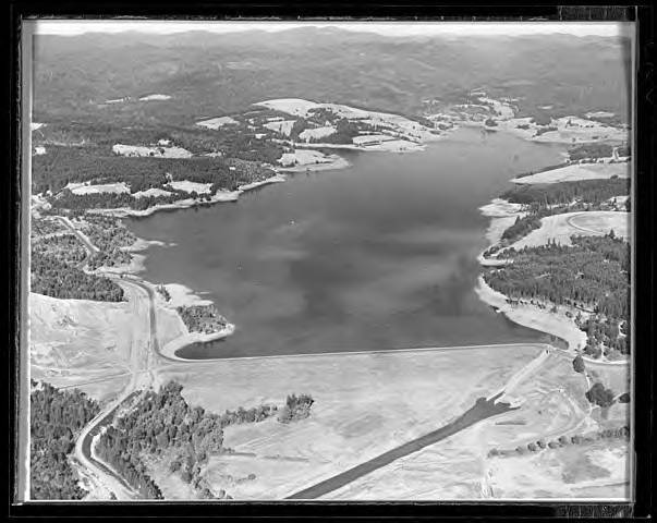
Black and white aerial view looking up Scoggins Dam and Hagg Lake. See WCMpic_013116 for a 'before' shot of the valley before it was flooded by the reservoir.
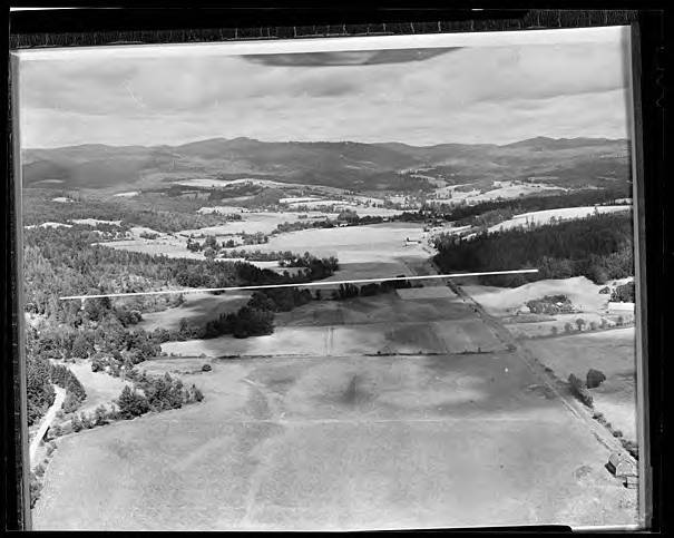
Black and white aerial view looking up Scoggins Creek valley. The white line across the middle of the image shows where Scoggins Dam will be built. Visible in the background are several farms and other buildings which would be inundated as the reservoir filled. See WCMpic_013117 for an 'after' shot of the valley that shows the reservoir after it was filled.
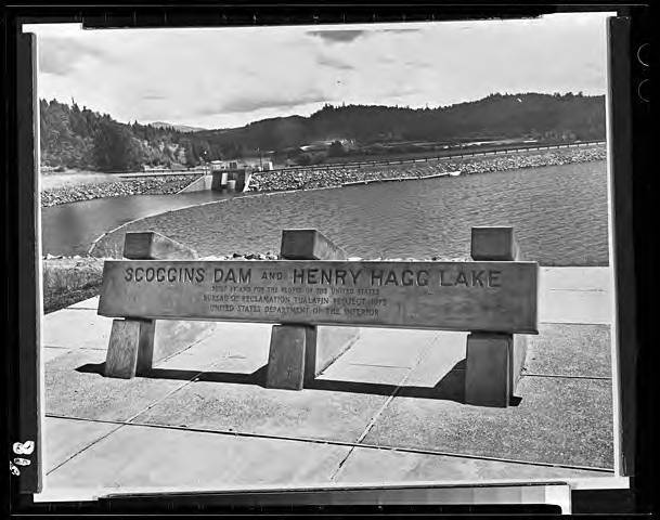
Black and white image of a concrete sign for Scoggins Dam and Henry Hagg Lake. The dam and the spillway opening can be seen in the background. Scoggins Dam and Henry Hagg Lake were constructed as a part of the a larger project to provide drinking water and irrigation for farms and communities in the Tualatin River watershed. Construction on the dam began in June of 1972, and the lake was opened for public recreation in the summer of 1975. Washington County maintains the recreation area and the dam with the help of the local Elks lodges, while the facilities and the lake are owned by the Bureau of Reclamation. Scoggins Dam is named for Gustavus Scoggin, whose family settled in what would become Washington County in 1848. Henry Hagg was a long time resident of the Scoggin Valley and had been one of the original initiators of the Scoggins Dam project in 1934.
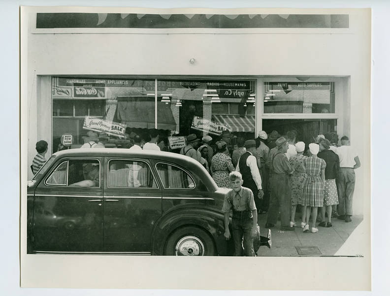
A small crowd stands outside of the Farm Home & Auto Supply grand opening. The store sells hardware, home appliances, Firestone tires, radios, house wares, paint and auto supplies.
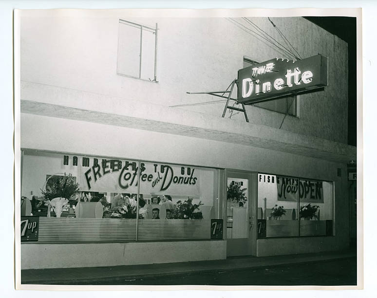
Exterior photograph of the grand opening of The Dinette in Hillsboro. Several patrons are visible through the windows. On the windows are signs advertising 'Hamburgers to go,' 'Free Coffee and Donuts,' 'Fish and Chip's,' and 'Now Open.'
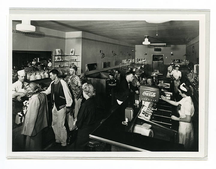
Black and white image showing the busy interior of a shop with a soda fountain on one side and a candy counter on the other. Three women in white uniforms and hats serve customers at the soda fountain while a man in an apron and hat waits on customers at the candy counter. Originally located on Third Avenue in Hillsboro, the Bennett's relocated to Main Street when the owner of the newly renovated Hill Theater asked them move into one side of the theater and sell snacks to movie goers. The two young men at the candy counter are identified in museum records as Ray and Gene Rothstrom, while the man at the fountain counter is Gene Ruecker, at one time the mayor of Hillsboro. The middle woman behind the counter is Mary Jane Kovaly, while Joyce Hartrampf runs the soda machine.